Summary for Latitude53.428453 Longitude-2.159745 Easting389483 Northing392419 Grid referenceSJ894924 UTM reference30U 555829 5920263 Altitude78 metres (257 feet)
|
National Distribution
Logged-on? click on dot to query records. Please note our
Terms of Use. Double-click on map to go to region
Terms of Use. Double-click on map to go to region
View time series maps for Latitude53.428453 Longitude-2.159745 Easting389483 Northing392419 Grid referenceSJ894924 UTM reference30U 555829 5920263 Altitude78 metres (257 feet)
Identification difficulty rating: 4
Identification difficulty rating: 4
1992-on hectads: 0
Pre-1992 hectads: 0
Total hectads: 0
Explore Regional Distribution
Please log on and add a note on this species
About this species
Recorded altitude range
Species text
to be written
Adult Season
no detailed adult season data available
Habitats
background methodologyno broad habitat data available
no subhabitat data available
no structural habitat data available
no habitat detail or method data available
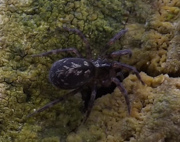
Images
sorry, no pictures available for this species yet - if you have an image please log on and upload it
See also A-Z Species Index - A-Z Picture Index - |